Location
Land tenure
Site status
Physical features
Biological features
Cultural and historical features
Access and visitor facilities
Summary of site features
Location
Grid reference:NZ 264428 Map
Flass Vale (approx 5 hectares) is situated within the boundary of Durham City approximately 1 km from the city centre at 87m above sea level. It lies between a ridge running north/south from Neville’s Cross to Sniperly (route of A167) and the area known as Western Hill. The south end of the vale is occupied by a housing development (formerly a bus garage) and a hotel/restaurant – the King’s Lodge, (formerly the Rose Tree). Flass bungalow (built 1930’s) and two large houses (built 2004) are situated in the south west corner of the Vale.
Land tenure
Most of the land east of the footpath leading from Flass House to the top end of the Vale is owned by Durham County Council. The land to the west of the footpath is in multiple ownership.
Site status
Most of the land to the west of the Flass House footpath is Common land.
Flass Vale was designated as a County Wildlife Site in 1982, and minor boundary changes have been submitted to Durham County Council for consideration.
Physical features
Flass Vale lies within the central Durham coalfield over coal measure shales. It is a moderately steep sided valley formed at the end of the ice age. The soil is mostly sand and clay glacial drift. Flass burn runs from north to south and is culverted beneath the housing development. A section of the Vale was used to tip rubble during the 1940’s.
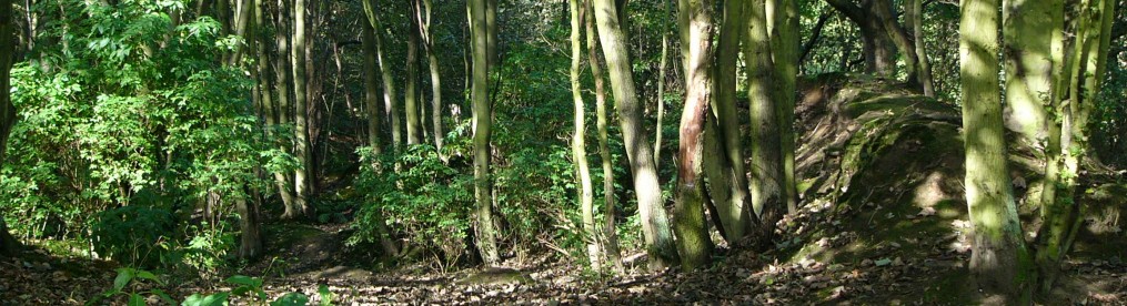
Biological features
The steep sided slopes of the Vale support semi natural broadleaved woodland. Much of the valley bottom and some of the slopes was pasture and is now grassland in various stages of succession. The lower end of the valley bottom is waterlogged supporting remnant wet woodland/ bog vegetation.
An ecological survey was carried out in 2004-2005.
Cultural and historical features
The Maiden’s Bower – a bronze age barrow with historical links to the battle of Neville’s Cross – is situated near the south west corner of the Vale. The site of a former curling pond is visible at the northern end of the Vale. Part of the east side of the Vale was a formal garden (Shaw Wood gardens) at the end of the nineteenth century. The remains of a cottage and piggery and several field boundaries are visible. A main sewer runs from north to south through the vale to the west of Flass burn. Four disused sand quarries lie within the area of Flass Vale. There are a number of broken field drains.
In 1973 a campaign to ‘Save Flass Vale’ was launched by local residents which resulted in permission for housing beyond the King’s Lodge hotel being withdrawn. The area which had been flattened as a road surface was restored as a beech/Norway maple plantation and a herb rich meadow by Durham City Council. A comprehensive archaelogical report is available here.
Access and visitor facilities
Designated public footpaths run through the vale giving six access points at Flass House, King’s Lodge, Valeside, Larches Road, Flassburn Road and Durham Johnston School. A non-designated footpath thought to be part of the route taken by monks between Durham cathedral and Beurepaire in medieval times leads to the A167 from the top of the Vale. There are no visitor facilities.
We have produced a map of the walks in the vale. Please download from the link below.
A Walk around Flass Leaflet
Summary of site features
Woodland: Mature woodland dominated by oak with holly understory and ground flora of bluebells occupies most of the slopes. Hawthorn scrub has developed on the area with tipped rubble. Several areas are dominated by young sycamore.
Grassland: Several areas of grassland and tall herb vegetation occur within the Vale. Some of this grassland has been colonised by bracken, rosebay willowherb, bramble and /or Himalayan balsam. Some of it is beyond recovery but other areas are being managed to restore the grassland vegetation.
Wetland: Flass Burn has a low water flow in summer. Where drainage is impeded in the bog area small pools develop in winter which are used by amphibians. Flass bog could be restored as alder/willow carr. The former curling pond area supports some marsh vegetation especially around springs.
Cultural: Maidens Bower is an ancient monument and must be managed appropriately. Some field boundaries could be restored.